|
|
|
|
|
|
|
|
|
|
|
|
INTRODUCTION |
|
|
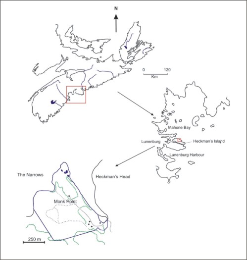
The Morton Centre is a 40 hectare property near Blue Rocks in Lunenburg, Nova Scotia (Figure 1). This property was donated to Acadia University by Dr. Harry Morton and his wife Rachel in 1995. Included with the property were existing structures. |
|
|
Until 1960, the Morton Centre property was in use as an active farm. The property was also logged extensively between the 1940s and the 1960s. After purchase by the Mortons in 1960, the property was used primarily as a summer home. Logging continued, though selective practices were used. In addition, the property continued to support agriculture as pastureland and hayfields. |
|
|
Figure 1: Location of the Morton Centre Property |
|
|
In the summer of 2002, a pilot project was developed for the property. This project was designed to provide data in order guide future development of the project. The preliminary resource inventory team consisted of four students working with several objectives: |
|
|
Objective 1 To permanently establish a baseline grid system for mapping the Morton Centre property in order to maintain sampling consistency over time. Although future projects may group or subdivide grid cells, the initial structuring will determine the baseline for future sampling. |
Objective 2 To complete a broad overview of the diversity of flora, fauna, geological elements and ecosystem structures present within the boundaries of the property and determine a procedure and sequence for detailed data collection and characterization.
|
|
|
|
|
|
|
|
Objective 3 To conduct a general assessment of the factors having impact on the property – i.e. adjacent property uses; movement of species; human and human sponsored animal use; weather patterns; etc. |
Objective 4 To conduct a systematic review and identification of ecological elements found within each grid cell of the property. The researchers will establish a protocol for level of detail and time of review in the initial stages of the project. Collection methods will include sampling as appropriate, digital images, and referenced observations. |
|
|
|
|
|
|
|
Objective 5 To design and build a computerized database for the property reflecting the grid structure and the ecological inventory. This will be done in close collaboration with the AITT and experts in GIS resources. |
Objective 6 To liaise with other researchers and community groups in the area to share information and data. |
|
|
|
|
|
|
|
Objective 7 To participate in the development of a business plan for the property, a strategic impact assessment for the property, Environmental Science field activities and problem based learning modules for Environmental Science. |
Objective 8 To prepare a final report for the summer project and participate in the development of interpretive and display materials for the Morton Centre. |
|
|
|
| Last Update: December 12th, 2003 | |